 |
Archaeological Excavation in Baden-Wurttemberg |

An enclosed Bandkeramik village and cemetery from the 6th millennium BC near Vaihingen/Enz
(Baden-Württemberg, Germany)
The town of Vaihingen is located on the western periphery of the middle Neckar region (between Stuttgart and Karlsruhe) in southern Germany. In 1994 excavation began in an area where future industrial building was planned. A complete Bandkeramik settlement with several burial places was discovered, extending over a total area of 8-10 ha (20-25 acres). The site, cut by a country road, is located between the deep valley of the river Enz and a gentle slope of the foothills of the Stromberg range.
 |
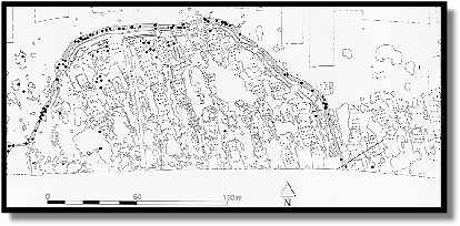
| The settlement. The black dots showing the burials in the ditch |
To the south, the extent of the settled area was determined in 1994 through three trial trenches, and most notably through systematic aerial prospection by Otto Braasch. In this part of the site, the advanced state of erosion in the settlement features, evident from the aerial photographs, was confirmed by excavation in 1998. Initially a rescue excavation, archaeological work at the site developed into an interdisciplinary project, with the participation of scientists from several subjects.
Results from the 1998 excavation have supplied
further information about the form, size and extent of the
ditch. It is apparently of an elongated oval form, with an
additional projection in the south-east of the excavated area. Accordingly, the
ditch has an east-west axis of 200 m, while reaching a maximum of 150 m on the
north-south axis. Smaller ditches for palisades accompany the ditch at regular
intervals of 1.0 and 3.0 m and their alignment with the ditch indicates that
both are most likely contemporary.
The northern settlement area, enclosed by the ditch and bordering on the
country road to the south, spreads over an area of almost 1.5 ha. Together with
the settlement area south of the road as well as more traces of the ditch found
in the spring of 1998, the total area within the enclosure could hardly have
exceeded 2 hectares (5 acres).
Recognizable in the general plan of the site, especially in the area enclosed by the ditch, are a dense accumulation of structures with numerous pits or pit groups, long trenches running laterally to the houses, and many house plans. House construction was contained within the western and northern boundaries of the ditch and rarely extended beyond; the few house plans found outside the area were earlier or later in date. Small pits are all that remain in the western area, and they, like the house contexts, were severely eroded. There the original location of houses is evidenced only by the remaining ditches, which once ran alongside their outer walls.
The present situation provides essential parameters for interpreting the history of settlement on the site. Basic questions pertain to the number of houses or economic units present simultaneously inside the ditch, the cause of the site’s abandonment, and the size of the settlement at its high point and period of greatest expansion.
 Until 1997 we assumed that the phase with the village ditch
represented the earliest building phase. This was based on the position of the
majority of house plans in relation to the ditch, and the later use of the
ditch as a cemetery. Examination has now clearly shown that to
the west, and even more so to the east, the settlement extended beyond the
ditch, either before the construction of the earthwork or else after it stopped
being used as an enclosure. Specifically on the eastern perimeter of the ditch,
a considerable time span is evidenced through at least three
consecutive situations. Eight burials in contracted position, discovered during
the campaign of 1996, were overlain by a longhouse. The whole
context accounts for at least three main phases relevant to the
settlement’s history: the erection of the village ditch, with palisades as
well as structures inside the enclosure; the later use of the infilled ditch as
a cemetery; and the earlier and later phases of house construction.
The conclusion reached during the first campaigns of excavation, that the settlement as well as the encircling ditch represents the beginning of activity on the site, has been revised by the new results. Construction of the ditch was undertaken at a time when the settlement had already been established. Indeed, the settlement plan gives the impression that the ditch was dug around an area already occupied by houses. The pottery found in the ditch fill also confirms that it was in use for a comparatively short time - perhaps one or two generations - before the structure was totally dismantled, the ditch filled in, and thereafter used as a cemetery.
A surprising discovery was that of 120 Bandkeramik graves, found either in the ditch itself or in pits adjacent to it. In all, around 80 human burials were found in all layers of the ditch fill. A further 40 skeletal remains (human and animal) were discovered mainly in various other pits, mostly in the vicinity of the ditch or in the lateral house trenches. The dead were usually buried in a contracted position, with the extremities drawn in close to the body. A few examples give the impression that the dead were simply thrown into the pits. Grave goods or the remains of personal ornaments are exceptional; some pots were found, but more frequently it was single sherds.
The majority of settlement structures and the ditch can be dated to the earlier phase of the Bandkeramik, the so-called Flomborn phase, and to the beginning of the middle Bandkeramik. In many instances, excavation supplied important stratigraphic information, which was supplemented by the results from Hans-Christoph Strien’s pottery chronology.
The excavation will be continued in 1999.
(Text: Dr. Rüdiger Krause, translated by Emily Schalk)
read also:
6 March 1999 - If you have any comments or questions, please contact me: Wolfgang M. Werner wmwerner@web.de